Mapping where we really go, and who we really talk to
 Here’s a map of the NCPR coverage area but this column is not about where our signal goes or who listens…at least I don’t think it’s about that.
Look at the map and try to draw a boundary around your most common travel routes. There used to be a comic strip called, I think, “The Family Circus,” in which the artist would often draw the circuitous route of a child’s activities around the house and yard over the course of a day.
This is kind of what I’m asking you to imagine–only think about a typical week or month.
If you live in Watertown, is your regional travel bordered by Clayton or Kingston, Fort Drum, and Adams most days?
If you’re in Plattsburgh, is the shape of your regular travel cornered by Burlington, Elizabethtown and Malone?
Get the idea?
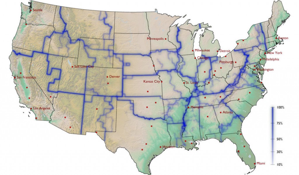
What started this was a wonderful blog entry from NPR’s Robert Krulwich Sarah Harris sent me last month. Krulwich, citing the work of German physicist Dirk Brockman, explores the notion of “whom do you hang with” based on how money moves around regions of our country. Here’s Brockman’s map:
As Sarah pointed out, it looks like northern NY is in the large East Coast band of interaction; while Vermont is firmly within the New England/Boston sphere of influence.
The more muted blue lines indicate money “sloshing around” within a region, but the darker blue borders are really hard and fast in terms of keeping money from moving outward.
Later in Krulwich’s post, he explores another study that tracked phone usage as the basis for visual mapping of our social interactions.
Okay, so back to the beginning.
What’s your home base, where do you go and where do you spend money on a regular basis? And, with whom do you have the most phone interaction–people within your home community or family and friends who live elsewhere?
Tags: community, mapping, ncpr, robert krulwich


.png)


Think this could be an interesting study and show how these mountains physically – and demographically and socially – divide up the region.
We live Johnsburg, NY, but I work in Glens Falls. Also, we do most of our shopping in Glens Falls. Friends we hang with: 70% Johnsburg/North Creek, 10% other Adirondacks and 20% Glens Falls.
I live in Indian Lake and work in Glens Falls. I interact along that travel corridor mostly in Johnsburg or Minerva. Some in Warrensburgh and Thurman, then Chestertown and Horicon, then Schroon Lake and North Hudson. Occasionally I’ll get to Newcomb. Phone interaction is largely in the same areas except those in far flung places like Va. and Ca. I’ll get to those folks by e mail as well. Interesting study. Hope it keeps a dollar or two from hitting that huge downstate siphon. If we could do buisness more with Vt. it would seem to be better for both areas.
I pretty much stay within Hamilton County and only leave when forced to leave to buy something in Glens Falls I can’t find here. Most of my money stays here. As far as phone calls go, as few as possible, mostly for business and those are almost always within Hamilton County.
The only exception is a trip or two per year to NYC to visit family and friends.