


New off-road views online
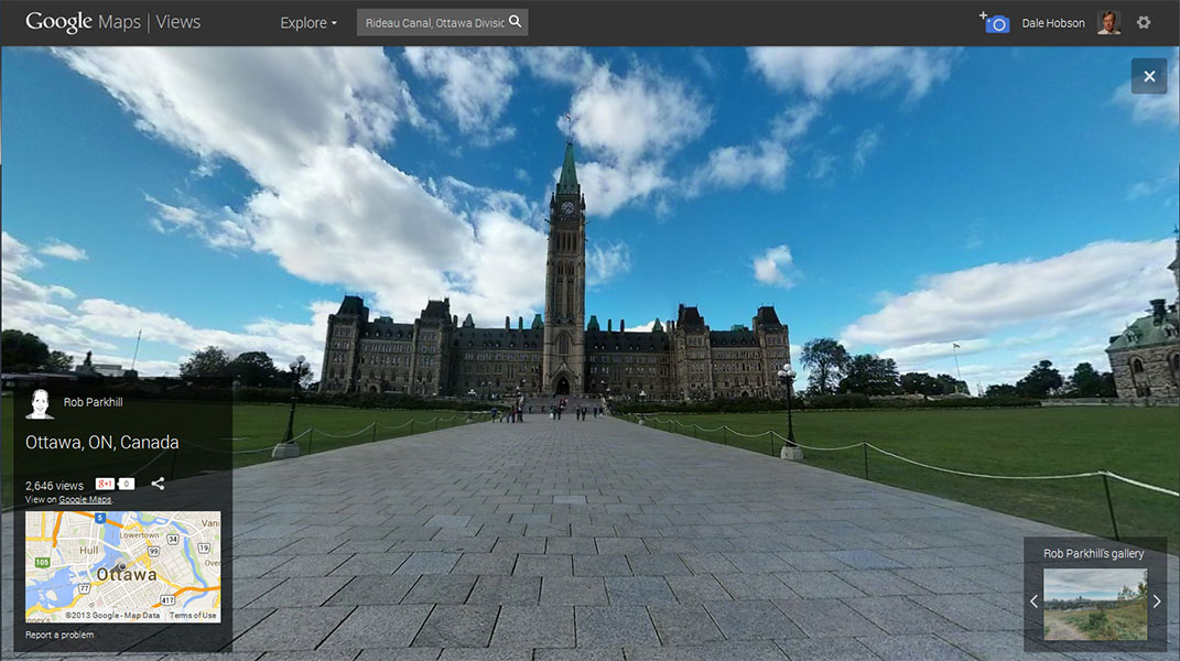
Screen shot from a Street View panorama of Parliament Hill by Rob Parkhill
More and more of the world is getting captured in some internet image format.
I must confess to having mixed feelings about the trend. It seems like a collision – between access to information verses retaining some degree of control, privacy…mystery?
There’s some adage about “just because something is possible doesn’t necessarily mean it should be done”. (Although that also raises the question of who decides what should or should not happen!) We are becoming almost God-like, in terms of reach. Without comparable leaps in wisdom or restraint, I fear.
Despite nagging misgivings, I use on-line information – all the time! Heck, I haunted street view when researching our downsize the last time we moved. (I’d find a likely house for sale in the real estate listings and then scout the surroundings via Google Maps or Bing.) Most of what I do for NCPR blogs is internet dependent. It is quite useful.
Here’s the Street View site and here’s what Wikipedia has to say about it. (Disclaimer: although this discussion mentions Google by name it is not intended as an endorsement or ad.) Anyway – like it or not – new visual acquisitions keep coming, including more from natural or historic locations in Canada.
Hikes through spectacular national parks such as Banff and tours of historic sites such as the Viking settlement at L’anse au Meadows in Newfoundland are now available on Google Street View.
Google and Parks Canada announced today that more than 70 Parks Canada locations across the country can now be explored online.
This CBC report from August looked at how Google’s backpack camera rendered the Rideau Canal and the Google trolley roamed the legislative chambers on Parliament Hill.
The October issue of on-line magazine Thousand Islands Life wrote up a similar effort there:
This past August (2013), a Google specialist spent 3 days trekking around Thousand Islands National Park capturing 360° panoramic images of the very best the park has to offer. The Google “Trekker” is essentially a backpack with a camera system, like those on the Google Street Car. It takes multiple images at the same time, which are then seamlessly edited together to create routes that people can navigate and follow online.
(Note: The article states it may take up to a year for those images to be available.) According to CBC, Google picked up the tab for the project, with some enthusiastic endorsement from Parks Canada, which hopes to boost visitor traffic. (By the way, although the publicity implies hike-like image movement, when I tried to find those most of what was available seemed to be single-spot panoramic views, like this one from the Fortress of Louisbourg, in Nova Scotia. I am still looking for full hikes.)
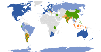
dark blue – mostly full coverage
light blue – partial coverage
dark orange – full or partial coverage planned (official)
light orange – full or partial coverage planned (unofficial)
green – iews of selected tourist attractions only
grey – no current or planned coverage (Source: Wikipedia)
Of course, this is happening in more and more countries. Students, armchair travelers or those planning their own adventures will soon be able to do a computer “walk” through Machu Pichu, for example. (That link is to a Spanish article, here’s more discussion of that in English. I only speak a few words in Spanish, but it’s getting easier and easier to translate information on line.)
As best I can tell, the Adirondacks are still mostly rendered as photos or panoramas from specific spots, like this one of High Falls, by Eric McDonough.
Do you like this enhanced access? Do you use it? Would you like all the High Peaks (for example) hiked by the trekker camera?
How would you frame the pros or cons of putting so much of our world on line?
Tags: canada, Google Street View, internet privacy, regional information, rideau canal, Thousand Islands, tourism, travel


I like street views. They have allowed me to see places where I once lived are still there.
And what is the difference between watching a movie about places you might like to visit and seeing those same place online?
I’m waiting (maybe I should do it) for people to buy a drone, attach a camera to it, and hike the mountains from the trail head, filming their adventure without working up a sweat.
Knowing everything before visiting a place takes away that sense of discovery. I did a piece for the NCPR.org All In blog a couple months ago called “The Cheap Hikes” (http://blogs.northcountrypublicradio.org/allin/2013/08/14/the-cheap-hikes/), my list of relatively easy mountain summits to climb in the Adirondacks, my version of a trail guide…but I didn’t do much guiding. I made a point in the post that I was not going to give much information – the visitor/hiker had to discover stuff on their own (I included no images from the summits of the mountains I featured) If I’m never going to get to a specific spot, maybe checking it out in one of these google/panorama images might be kinda nice, but I think there needs to be some mystery to a place, something to discover only when you actually get there.