by
Brian Mann on April 28th, 2011
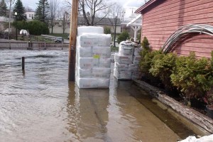
 We’re getting reports of serious flooding across much of the North Country. We’re interested in hearing what you’re seeing at your home or business this morning.
What’s the weather? What are your roads like? What’s the status of the river closest to you? Check out our news page for our latest reports from around the region.
It’s been an amazing night and morning here in Saranac Lake, with thunder and lightning and periodic deluges. This is not the weather emergency officials were hoping for.
Chime in and let us know what’s happening in your area.
Tags: flooding
I just heard that Rt 30 between Blue Mtn and Long Lake is closed
Essex County reports that NYS Route 73 is closed due to water over the road, but I don’t know where. I took a lot of photos yesterday of high water and scoured banks where water had retreated, guess I’ll go out for more soon.
It is flooding everywhere. It might be time to consider building an Arc.
Flooding in Keene Valley. Route 73 at bridge over Johns Brooke is closed. Crazy corners on Route 73 also closed
A friend who should know told reports that the main bridge through Moriah Center has washed out, after the one in Port Henry lost yesterday. This means that two of main access roads for Moriah Central School are now blocked, and the only other , Rt. 9N, is under water. And it’s still raining.
Rain, rain go away. Come back in a few weeks.
In the village of Potsdam, the water has been high for two weeks and is a tad higher today. There’s a bit of flooding in the parking lot at the Market Square Mall and yards are flooded below the dam at the end of those streets west of Market. The word around town is that they’ll be opening the gates a bit at Carry Falls Reservoir…That should make it interesting the rest of the way down…all the way to Massena.
It’s not flooding at my house ,but if it were, there would be white caps .
The VT side of Lake Champlain is really high. I went to St. Albans Bay a week ago and the water was probably a couple feet below VT Route 36. I suspect it is overtopped now.
I-89 between the winooski and islands exits dips near the lake level. In the spring, the west side of the southbound lane gets inundated a bit, but this year the median has standing water in it. Another couple feet and the interstate will be submerged.
The winooski river is ripping. Absolutely bank-full.